Waypoints define a route's stopovers, including its start point it's destination point and any points in between.
More...
#import <SYRoutingWaypoint.h>
|
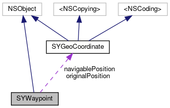
| SYGeoCoordinate * | originalPosition |
| | Position for flag/pin. The original position is required for a route calculation. By default, this is set to be the same as the geocoordinates provided during construction of this SYWaypoint. More...
|
| |
| SYGeoCoordinate * | navigablePosition |
| | Represents the suggested navigable position of the SYWaypoint - typically the coordinates on the road closest to the original position - to be used in a route calculation. Working together with the navigable position, the original position is used by the Sygic SDK for determining the side of street during arrival, and to let the calculated route approach the correct side of street, especially when there there is a physical or logical lane divider on the road. More...
|
| |
| SYWaypointType | type |
| | Determines the waypoint type. More...
|
| |
| SYWaypointStatus | status |
| | Determines if waypoint is reached or not. More...
|
| |
| NSString * | name |
| | Waypoint's name. More...
|
| |
| SYDistance | distanceFromStart |
| | Distance from route start. More...
|
| |
Waypoints define a route's stopovers, including its start point it's destination point and any points in between.
◆ initWithPosition:type:name:()
| - (nonnull instancetype) initWithPosition: |
|
(nonnull SYGeoCoordinate *) |
position |
| type: |
|
(SYWaypointType) |
type |
| name: |
|
(nullable NSString *) |
name |
|
|
| |
Initializes a SYWaypoint instance with specified geocoordinates and type.
◆ initWithSDKWaypoint:()
| - (instancetype) initWithSDKWaypoint: |
|
(Sygic::Router::WaypointPtr) |
waypoint |
|
◆ sdkWaypoint()
◆ distanceFromStart
| - (SYDistance) distanceFromStart |
|
readnonatomicassign |
Distance from route start.
◆ name
◆ navigablePosition
Represents the suggested navigable position of the SYWaypoint - typically the coordinates on the road closest to the original position - to be used in a route calculation. Working together with the navigable position, the original position is used by the Sygic SDK for determining the side of street during arrival, and to let the calculated route approach the correct side of street, especially when there there is a physical or logical lane divider on the road.
◆ originalPosition
Position for flag/pin. The original position is required for a route calculation. By default, this is set to be the same as the geocoordinates provided during construction of this SYWaypoint.
◆ status
| - (SYWaypointStatus) status |
|
readnonatomicassign |
Determines if waypoint is reached or not.
◆ type
Determines the waypoint type.
The documentation for this class was generated from the following file:
 1.8.16