- Developers
- Professional Navigation for Fleets
- Android
- API
- Routing API
Routing API
Overview
Routing API is about to work with routes and itineraries using json file format.
There are functions, which allow sending json route or itinerary for route calculation and subsequent navigation,
and functions, which allow retrieving actual route real-time status either at a detail of waypoints or even geometry.
You can create a new itinerary through AddItinerary or delete an existing one through DeleteItinerary.
Itineraries are defined with a list of waypoints, each represented primarily with gps coordinates and optionally with a time window, which defines a desired visiting time. And then you can send itinerary to navigation through SetRoute and in real time to monitor the itinerary execution through GetRouteStatus. The exact route geometry calculated by routing engine can be retrieved through GetRoute.
You can also load a route generated in an external system through LoadComputedRoute and put it to navigation. There are few json as well as other formats specified for the import. External routes are defined with a list of waypoints along with an exact geometry to be followed in between waypoints. Such route can be monitored during navigation at a waypoint level through GetRouteStatus as well as with a full geometry by GetRoute.
The itinerary and route functions operate with several json objects, namely:
- Json itinerary object is used with AddItinerary, SetRoute
- Json route object is used with LoadComputedRoute, GetRoute
- Json status object is used with GetRouteStatus
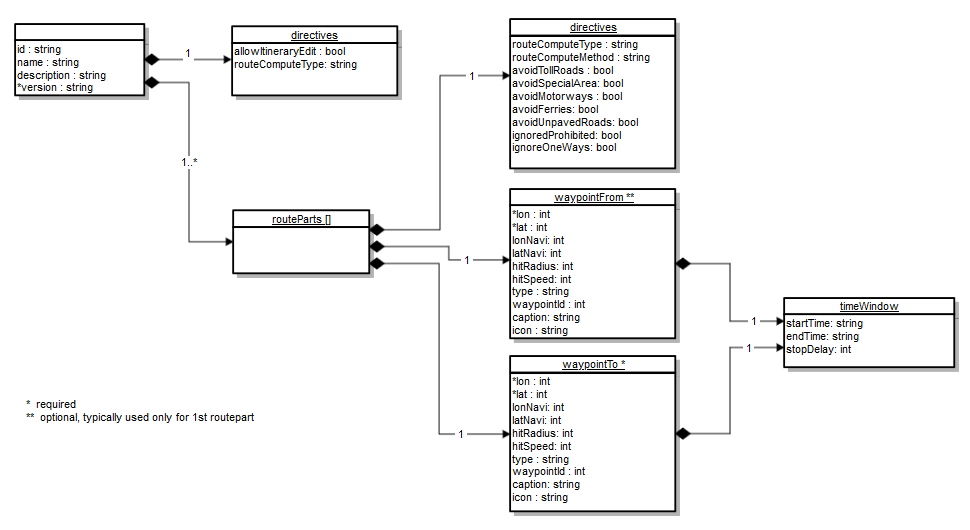
Itinerary object (.sif)
The json specification of the supported structure is shown in the diagram bellow.
The fields denoted with * are mandatory.

Table of json fields
| Field | Type | Default value | Description |
|---|---|---|---|
| id | string | itinerary identifier | |
| name | string | name of the itinerary | |
| description | string | short description | |
| version | string | file format version, supported are: 2.1, 2.2 | |
| allowItineraryEdit | bool | true | allows or disallows manual edit of itinerary once loaded into navigation |
| routeComputeType | string: car|truck|bus|camper|van|pedestrian | car | defines the vehicle routing preference applied between waypoints or for the whole itinerary |
| routeComputeMethod | string: fastest|shortes|economical | fastest | defines the routing method preference applied between waypoints |
| avoidTollRoads | bool | false | defines the routing attribute for toll roads |
| avoidSpecialArea | bool | false | defines the routing attribute for special city zones |
| avoidMotorways | bool | false | defines the routing attribute for motorways/highways |
| avoidUnpavedRoads | bool | false | defines the routing attribute for unpaved roads |
| ignoreProhibited | bool | false | defines the routing attribute for ignoring prohibited maneuvers |
| ignoreOneWays | bool | false | defines the routing attribute for ignoring oneway driving rule |
| lat | int | 0 | latitude position defined as WGS84 multiplied by 100,000 |
| lon | int | 0 | longitude position defined as WGS84 multiplied by 100,000 |
| lonNavi | int | =lon | navigable longitude position defined as WGS84 multiplied by 100,000 |
| latNavi | int | =lat | navigable latitude position defined as WGS84 multiplied by 100,000 |
| hitRadius | int | 50 | distance in meters from the waypoint considered as visiting criteria |
| hitSpeed | int | 50 | reference speed at which hitRadius holds exactly, for higher speeds the hitRadius is linearly increased |
| type | string: start|via|finish | via | the type of waypoint |
| waypointId | int | -1 | user defined identification of the waypoint |
| caption | string | waypoint name shown in the route summary, by default the name is indicated by its exact address | |
| startTime | string | defines the starting time of a time window in the UTC format, example 2015-03-06T14:15:00Z | |
| endTime | string | defines the ending time of a time window in the UTC format, example 2015-03-06T14:30Z | |
| stopDelay | int | 0 | defines the service time in seconds expected to spent on the waypoint |
| icon | string: wp_fuel | wp_load | wp_unload | wp_pause | defines the icon display of the waypoint on map. The name referes to the png picture contained in the folder /Res/icons/waypoints, and is limited to the one of the four enumerated names. Example icon="wp_fuel" refers to "wp_fuel.png" or "wp_fuel_visited.png", thus requires both pictures to be available in the folder. |
Example of the itinerary with 3 waypoints:
{
"name":     "Itinerary-627",
"version":  "2.2",
"routeParts":
   [{
        "directives":
        {
            "routeComputeType": "car",
            "routeComputeMethod":   "fastest",
            "avoidTollRoads":       true,
            "avoidSpecialArea": false,
            "avoidMotorways":   false,
            "avoidFerries":             false,
            "avoidUnpavedRoads":    true,
            "ignoreProhibited": false,
            "ignoreOneWays":        false
        },
        "waypointFrom":
        {
            "timeWindow":
            {
                "startTime": "2015-06-16T14:00:00Z",
                "endTime": "2015-06-16T14:30:30Z",
                "stopDelay": 120
             },
            "lon":              1711001,
            "lat":              4814955,
            "type":          "via",
            "waypointId":   1,
            "hitRadius":    100
        },
        "waypointTo":
        {
            "lon":           1710758,
            "lat":           4814795,
            "type":          "via",
            "waypointId":   2,
            "hitRadius":    100
        }
   },{
        "directives":
        {
            "routeComputeType": "car",
            "routeComputeMethod":   "shortest"
        },
        "waypointTo":
        {
            "timeWindow":
            {
                "startTime": "2015-06-16T15:00:00Z",
                "endTime": "2015-06-16T15:30:30Z",
                "stopDelay": 120
            },
            "lon":              1710375,
            "lat":              4814391,
            "type":             "finish",
            "waypointId":   3,
            "hitRadius":    100
        }
    }]
}
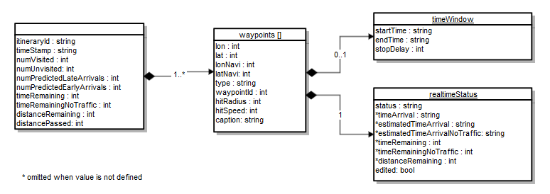
Itinerary status object
The specification of the supported json fields is shown in the diagram bellow. Some fields denoted by * can be omitted, which is in case the value is not valid. E.g. the field timeArrival when the waypoint is not yet visited.

Table of json fields
| Field | Type | Default value | Description |
|---|---|---|---|
| itineraryId | string | itinerary identifier | |
| timeStamp | string | - | the timestamp of the current status |
| numVisited | int | - | number of waypoints already visited. The start waypoint is counted too. |
| numUnvisited | int | - | number of waypoints not yet visited |
| numPredictedLateArrivals | int | - | number of waypoints predicted to have late arrivals |
| numPredictedEarlyArrivals | int | - | number of waypoints predicted to have early arrivals |
| timeRemaining | int | - | time in seconds estimated to reach the finish |
| distanceRemaining | int | - | distance in meters estimated to reach the finish |
| distancePassed | int | - | distance in meters passed from start |
| lat | int | - | latitude position defined as WGS84 multiplied by 100,000 |
| lon | int | - | longitude position defined as WGS84 multiplied by 100,000 |
| lonNavi | int | - | navigable longitude position defined as WGS84 multiplied by 100,000 |
| latNavi | int | - | navigable latitude position defined as WGS84 multiplied by 100,000 |
| hitRadius | int | - | distance in meters from the waypoint considered as visiting criteria |
| hitSpeed | int | - | reference speed at which hitRadius holds exactly, for higher speeds the hitRadius is linearly increased |
| caption | string | waypoint name shown in the route summary, by default the name is indicated by its exact address | |
| type | string: start|via|invisible|finish | - | the type of waypoint |
| status | string: visited|unvisited|none | - | the status of the waypoint |
| edited | bool | - | indicates whether the waypoint was manually edited since itinerary loading into navigation |
| timeArrival | string | - | defines the actual arrival time at the waypoint in the UTC format if already visited, example 2015-03-06T14:15:00Z |
| estimatedTimeArrival | string | - | defines the estimated arrival time at the waypoint in the UTC format if not yet visited, example 2015-03-06T14:30Z |
| realtimeStatus: timeRemaining |
int | - | time in seconds estimated to reach the waypoint |
| realtimeStatus: distanceRemaining |
int | - | distance in meters estimated to reach the waypoint |
Example of the itinerary status with 3 waypoints:
{
    "timeStamp": "2015-06-28T16:10:37Z",
    "numVisited": 1,
    "numUnvisited": 2,
    "numPredictedLateArrivals": 0,
    "numPredictedEarlyArrivals": 1,
    "timeRemaining": 1312,
    "distancePassed": 0,
    "distanceRemaining": 8610,
    "waypoints":
    [{
            "lon":  1711468,
            "lat":  4813110,
            "type": "start",
            "waypointId":   1,
            "hitRadius":    200,
            "timeWindow":
            {
                "startTime":  "2015-06-28T16:00Z",
                "endTime":  "2015-06-28T16:30Z",
                "stopDelay":  180
            },
            "realtimeStatus":
            {
                "status":  "visited",
                "edited":  false
            }
    }, {
            "lon":  1713067,
            "lat":  4816062,
            "type":  "via",
            "waypointId":  2,
            "hitRadius":  200,
            "timeWindow":
            {
                "startTime":  "2015-06-28T16:15Z",
                "endTime":  "2015-06-28T16:30Z",
                "stopDelay":  180
            },
            "realtimeStatus":
            {
                "status":  "unvisited",
                "estimatedTimeArrival": "2015-06-28T16:19:25Z",
                "timeRemaining":  528,
                "distanceRemaining":  5018,
                "edited":  false
            }
    }, {
            "lon":  1710000,
            "lat":  4814722,
            "type": "finish",
            "waypointId":   3,
            "hitRadius":    200,
            "timeWindow":
            {
                "startTime":  "2015-06-28T17:00Z",
                "endTime":  "2015-06-28T17:30Z",
                "stopDelay":  180
            },
            "realtimeStatus":
            {
                "status":  "unvisited",
                "estimatedTimeArrival":  "2015-06-28T16:29:29Z",
                "timeRemaining":  1132,
                "distanceRemaining":  8610,
                "edited":  false
            }
        }]
}
Route object
This json object is used with LoadComputedRoute for importing routes generated in external systems, e.g. the export of a Route Optimization software.
Disclaimer: Since app version 21.1.0 a new map matching algorithm is used for .json and .bcr (PTV) file format.
In order to use the legacy magnetic routing algorithm, simply rename the .json file extension to .omc (original magnetic compute) and load the .omc file instead.
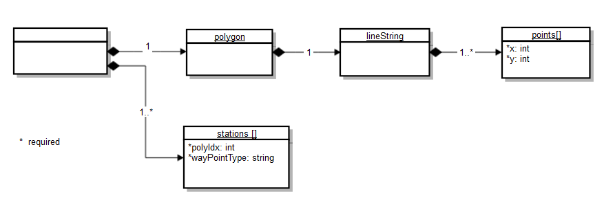
1. PTV-compatible format (.json, .bcr)
These files can be obtained through exports from PTV route calculation services, like xServer, etc.
The json specification of the supported structure:

Table of json fields
| Field | Type | Default value | Description |
|---|---|---|---|
| x | double | n/a | longitude position defined as WGS84 multiplied by 100,000 |
| y | double | n/a | latitude position defined as WGS84 multiplied by 100,000 |
| polyIdx | int | n/a | index reference to the points array defining the GPS point as the waypoint/station |
| WayPointType | string | n/a | the type of waypoint, possible values are START, VIA, DEST. |
Example
{
  "polygon": {
    "lineString": {
      "points": [
        {
          "x": 1712571,
          "y": 4814643
        },
        {
          "x": 1712486,
          "y": 4814651.5
        },
        {
          "x": 1712461,
          "y": 4814652
        },

...
        {
          "x": 1712302,
          "y": 4814263
        },
        {
          "x": 1712355,
          "y": 4814257
        },
        {
          "x": 1712468,
          "y": 4814248
        }
      ]
    }
  },
  "stations": [
    {
      "polyIdx": 0,
      "wayPointType": "START"
    },
    {
      "polyIdx": 44,
      "wayPointType": "VIA"
    },
    {
      "polyIdx": 83,
      "wayPointType": "DEST"
    }
  ]
}
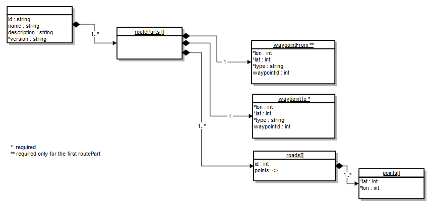
2. Sygic-native format (.sif)
The json specification of the supported structure (version 1.1) :

Table of json fields
| Field | Type | Default value | Description |
|---|---|---|---|
| name | string | "" | route name appearing in route info dialog |
| description | string | "" | route description appearing in route info dialog |
| version | string | n/a | used version, currently available 1.0 and 1.1 |
| lat | int | n/a | latitude position defined as WGS84 multiplied by 100,000 |
| lon | int | n/a | longitude position defined as WGS84 multiplied by 100,000 |
| type | string | n/a | the type of the waypoint, possible values are start, via, finish. |
| waypointId | int | -1 | user defined identification of the waypoint |
| id | int | -1 | user defined identification of the road |
Example
{
"name":     "Route-77",
"version":  "1.1",
"routeParts":
   [{
        "waypointFrom":
        {
            "lat":          4814951,
            "lon":          1711001,
            "type":         "start"
        },
        "waypointTo":
        {
            "lat":           4814791,
            "lon":           1710751,
            "type":          "via"
        }
        "roads":
        [
          {
             "id": 1,
             "points": [ { "lat": 4814952, "lon": 1711002 }, { "lat": 4814953, "lon": 1711003 }, { "lat": 4814954, "lon": 1711004 } ... ]
          },
          {  "id": 2,
             "points": [ { "lat": 4814955, "lon": 1711005 }, { "lat": 4814956, "lon": 1711006 }, { "lat": 4814957, "lon": 1711007 } ... ]
          }
          ...
        ]
   },{
        "waypointTo":
        {
            "lat":          4814391,
            "lon":          1710371,
            "type":         "finish"
        }
        "roads":
        [
          {
             "id": 25,
             "points": [ { "lat": 4814791, "lon": 1710751 }, { "lat": 4814792, "lon": 1710752 }, { "lat": 4814793, "lon": 1710753 } ... ]
          }
          ...
        ]
   }]
}
3. GPS Exchange Format (.gpx)
Open XML-based GPS data format used to describe routes
Example
<?xml version="1.0" encoding="UTF-8" standalone="no" ?>
<gpx xmlns="example">
<metadata>
<name>"Route example"</name>
<copyright author="example"></copyright>
<link href="example">
<text>"example"</text>
</link>
<time>2023-05-06T12:20:57Z</time>
</metadata>
<trk><name>"Route example"</name><trkseg>
<trkpt lat="50.888029" lon="6.841148"><ele>72.57</ele><time>2023-05-11T09:21:53Z</time></trkpt>
<trkpt lat="50.88816" lon="6.841233"><ele>72.0</ele><time>2023-05-11T09:22:14Z</time></trkpt>
<trkpt lat="50.888424" lon="6.841503"><ele>72.19</ele><time>2023-05-11T09:22:35Z</time></trkpt>
          ...
<trkpt lat="50.779975" lon="7.801081"><ele>219.9</ele><time>2023-05-11T11:11:43Z</time></trkpt>
<trkpt lat="50.779834" lon="7.800722"><ele>219.6</ele><time>2023-05-11T11:11:50Z</time></trkpt>
<trkpt lat="50.77984" lon="7.800591"><ele>219.95</ele><time>2023-05-11T11:11:57Z</time></trkpt>
</trkseg>
</trk>
</gpx>
AddItinerary
AddItinerary adds itinerary to the system database for immediate or later usage. It takes as an input json string, which defines the itinerary. The itinerary is basically a list of waypoints, each denoted as START, VIA or FINISH. Formally the itinerary is comprised of list of routeparts, while each routepart defines start and end waypoint.
Another input to the function is the name of the itinerary, which serves as a reference for function to put it into route calculation and navigation, which is SetRoute.
Check details of AddItinerary in the reference manual.
Please note AddItinerary with json support is only available with the 3D version of navigation.
Example
This example demonstrates how to create a new itinerary in a json format.
We create an itinerary with 3 waypoints, each defined with GPS coordinates, time windows and type of the waypoint.
The 3 waypoints are delivered in a ArrayList.
The result of the demo function is placing an itinerary into application ready to be used for navigation.
In the example we use the json library "json.org", which offers convenient manipulations with json strings and objects for construction and parsing.
For the definition of Sygic Json strings please refer to the section Json Itinerary object above.
    import org.json.JSONArray;
    import org.json.JSONException;
    import org.json.JSONObject;
    ...

    void demo()
    {
        ArrayList<TwWaypoint> lst = new ArrayList<TwWaypoint>();
        lst.add(new TwWaypoint(48.11468, 17.13110, "2017-06-28T16:00:00Z", "2017-06-28T16:00:00Z", "start"));
        lst.add(new TwWaypoint(48.13067, 17.16062, "2017-06-28T17:00:00Z", "2017-06-28T17:30:00Z", "via"));
        lst.add(new TwWaypoint(48.10039, 17.14722, "2017-06-28T18:00:00Z", "2017-06-28T18:30:00Z", "finish"));

        String json = CreateJsonItinerary(lst);
        String itname = "itin-63";
        try {
            ApiItinerary.addItinerary(json, itname, 0);
        } catch (GeneralException e) {
            e.printStackTrace();
        }
    }

    // Json construction and parsing helpers

    public class TwWaypoint {
        double lat;
        double lon;
        String dtStart;
        String dtEnd;
        String wpType;
        public TwWaypoint (double lat, double lon, String dtStart, String dtEnd, String wpType)
        {
            this.lat = lat;
            this.lon = lon;
            this.dtStart = dtStart;
            this.dtEnd = dtEnd;
            this.wpType = wpType;
        }
    }

    JSONObject createWaypoint(double lat, double lon, String time1, String time2, int waypointId, String wtype)
    {
        int ilat = (int)(lat * 100000);
        int ilon = (int)(lon * 100000);

        JSONObject obj = new JSONObject();
        try {
           obj.put("lat", Integer.valueOf(ilat));
           obj.put("lon", Integer.valueOf(ilon));
           obj.put("waypointId", Integer.valueOf(waypointId));
           obj.put("hitRadius", Integer.valueOf(200));
           obj.put("type", wtype);
           if (time1 != null && time2 != null)
           {
               JSONObject tw = new JSONObject();
               tw.put("startTime", time1);
               tw.put("endTime", time2);
               tw.put("stopDelay", Integer.valueOf(180));
               obj.put("timeWindow", tw);
           }
        }
        catch (JSONException e)
        {
            obj = null;
        }
        return obj;
    }

    JSONObject createRoutepart(JSONObject wpFrom, JSONObject wpTo)
    {
        JSONObject obj = new JSONObject();
        try {
           if (wpFrom != null) obj.put("waypointFrom", wpFrom);
           obj.put("waypointTo", wpTo);
        }
        catch (JSONException e)
        {
            obj = null;
        }
        return obj;
    }

    protected String CreateJsonItinerary(ArrayList<TwWaypoint> lst)
    {
        try {
            JSONArray routeparts = new JSONArray();
            JSONObject routepart;
            JSONObject wpFrom;
            JSONObject wpTo;
            for (int i = 1; i < lst.size(); i++)
            {
               wpFrom = null;
               if (i == 1) wpFrom = createWaypoint(lst.get(0).lat, lst.get(0).lon, lst.get(0).dtStart, lst.get(0).dtEnd, 0, lst.get(0).wpType);
               wpTo = createWaypoint(lst.get(i).lat, lst.get(i).lon, lst.get(i).dtStart, lst.get(i).dtEnd, i, lst.get(i).wpType);
               routepart = createRoutepart(wpFrom, wpTo);
               if (routepart == null) return null;
               routeparts.put(routepart);
            }
            JSONObject json = new JSONObject();
            json.put("name", "Bratislava-pickup");
            json.put("version", "2.2");
            json.put("routeParts", routeparts);
            return json.toString();
        } catch (JSONException e) {
              e.printStackTrace();
        }
        return null;
   }
DeleteItinerary
DeleteItinerary deletes the given itinerary from the system database referenced by its name.
Check details of DeleteItinerary in the reference manual.
    void demo()
    {
        try {
            ApiItinerary.deleteItinerary(json, "itin-63", 0);
        } catch (GeneralException e) {
            e.printStackTrace();
        }
    }
SetRoute
SetRoute sets the given itinerary referenced by its name for route calculation. And if successful, the navigation mode is immediately switched on and a driver is navigated over the waypoints.
Check details of SetRoute in the reference manual.
Example
The example creates an itinerary with 3 waypoints (using a self-made function CreateJsonItinerary) and passes it to the navigation
void demo()
{
    ArrayList<Waypoint> lst = new ArrayList<Waypoint>();
    lst.add(new Waypoint(48.15655, 17.12260, "start"));
    lst.add(new Waypoint(48.15174, 17.12490, "via"));
    lst.add(new Waypoint(48.15259, 17.12301, "finish"));
    String json = CreateJsonItinerary(lst);
    String itname = "itin-63";
    try {
        ApiItinerary.addItinerary(json, itname, 0);
        ApiItinerary.setRoute(itname, 0, 0);
    } catch (GeneralException e) {
        e.printStackTrace();
    }
}
Example
This example shows the error generated due to passing an invalid waypoint into the itinerary.
Invalid means either a non-existent GPS position or though existing but not reachable within the currently loaded map.
The error message also identifies the first problematic waypoint by index, which is defined in the ascending order starting from 0, while the start waypoint has the index -1.
The below example should produce the message Error -9:waypoint [0] from itinerary was not found
void demo()
{
    ArrayList<Waypoint> lst = new ArrayList<Waypoint>();
    lst.add(new Waypoint(48.15655, 17.12260, "start"));
    lst.add(new Waypoint(47.17250, -35.5307, "via"));      // middle of the ocean
    lst.add(new Waypoint(48.15259, 17.12301, "finish"));
    String json = CreateJsonItinerary(lst);
    String itname = "itin-64";
    try {
        ApiItinerary.addItinerary(json, itname, 0);
        ApiItinerary.setRoute(itname, 0, 0);
    } catch (GeneralException e) {
        Log.i("Error", e.getCode() + " " + e.getMessage());
    }
}
GetRouteStatus
Example
This example demonstrates how to retrieve current status of the itinerary execution, here placed into a user-defined formatted string.
When retrieving the execution status we can read out e.g. the information about the number of visited and unvisited waypoints, and then per each waypoint more detailed info such as ETA, remaining distance and time to the waypoint, etc.
In the example we used the json library json.org, which offers convenient manipulations with json strings and objects for construction and parsing.
Check details of GetRouteStatus in the reference manual.
Please note GetRouteStatus is only available with the 3D version of navigation.
   void demo()
   {
    String status;
    try {
        status = ApiNavigation.getRouteStatus(0);
    } catch (GeneralException e) {
        e.printStackTrace();
        return;
    }
    ParseRouteStatus(status);
   }

   protected String ParseRouteStatus()
   {
        try {
            JSONObject jout = new JSONObject(ret);
            String n1 = jout.getString("numVisited");
            String n2 = jout.getString("numUnvisited");
            String n3 = jout.getString("numPredictedLateArrivals");
            String n4 = jout.getString("numPredictedEarlyArrivals");
            JSONArray jArr = jout.getJSONArray("waypoints");

            String output = "visited/unvisited/early/late:" + n1 + "/" + n2 + "/" + n3 + "/" + n4 + "\n";
            for (int i=0; i < jArr.length(); i++)
            {
                JSONObject obj = jArr.getJSONObject(i);
                String waypointId = obj.getString("waypointId");              // retrieve waypoint id
                JSONObject rts = obj.getJSONObject("realtimeStatus");
                String status = rts.getString("status");                      // retrieve status
                String eta = "n/a";
                int drem = -1;
                int trem = -1;
                if (status.compareTo("unvisited") == 0)
                {
                   eta = rts.getString("estimatedTimeArrival");     // retrieve eta to the waypoint
                   drem = rts.getInt("distanceRemaining");          // retrieve remaining distance in meters
                   trem = rts.getInt("timeRemaining");              // retrieve remaining time in seconds
                }
                output += "waypointId=" + waypointId + ",";
                output += "status=" + status + "\n";
                output += "eta=" + eta + "\n";
                output += "distanceRemaining=" + String.valueOf(drem) + "\n";
                output += "timeRemaining=" + String.valueOf(trem) + "\n";
            }
            return output;

        catch (JSONException e) {
             e.printStackTrace();
        }
        return null;

   }
LoadComputedRoute
LoadComputedRoute imports a given route referenced by its filename into navigation engine. And if successful, the navigation mode is immediately switched on and a driver is navigated over the waypoints and following the route geometry in a magnetic way.
In case a deviation from route occurs the recalculation is triggered, which tries to navigate driver back to the original route in a most efficient way.
Check details of LoadComputedRoute in the reference manual.
Please note for the function to work the license file must contain the permission: precomputedRoutes=yes, otherwise the exception license error is raised.
Example
void demo()
{
    String filename = getSdcardStorage() + "/routes/route_66.json";
    try {
        ApiNavigation.loadComputedRoute(filename, 0);
    } catch (LoadRouteException e) {
        e.printStackTrace();
    }
}
GetRoute
GetRoute retrieves currently calculated route, containing waypoints and geometry, in a json string.
If there is no route calculated the functions returns exception.
Check details of GetRoute in the reference manual.
Example
The sample code retrieves the route geometry in the PTV format.
class GpsPoint
{
    double lat;
    double lon;
}

void demo()
{
    String json = null;
    try {
       json = ApiNavigation.getRoute(1, 0, 0);
       ArrayList<GpsPoint> gps = ParseToPolyline(json);
    }
    catch (GeneralException e) {
       e.printStackTrace();
    }
}
CalculateRoute
CalculateRoute executes route calculation(s) in a background possible for multiple origins and destinations, resulting in a so called distance matrix (a.k.a distance/time matrix). The calculation is a background process and does not affect a currently calculated route used for navigation.
The input is defined as a json structure expressing origins and destinations, and the output is produced in a json structure expressing distance and duration for each origin-destination pair as shown bellow. The distance is given in meters and the duration in seconds. In case a specific origin-destination cannot be calculated (typically due to out of map problem or map discontinuity) the distance and time results are given as -1, as well as the result value is different from 1.
Please note the function is currently availabe only in a beta release and will appear in the coming release 13.7.2.
Json input and output
Example with 2x2 matrix is as follows
Input
{
  "origins": [
    {
      "lat": 48.11,
      "lon": 17.13
    },
    {
      "lat": 48.12,
      "lon": 17.12
    }
  ],
  "destinations": [
    {
      "lat": 48.13,
      "lon": 17.11
    },
    {
      "lat": 48.12,
      "lon": 17.10
    }
  ]
}
Output
{
"distanceMatrix":[
{"origin": 0, "destination": 0, "result": 1, "duration": 745, "distance": 3669},
{"origin": 0, "destination": 1, "result": 1, "duration": 487, "distance": 3946},
{"origin": 1, "destination": 0, "result": 1, "duration": 243, "distance": 1971},
{"origin": 1, "destination": 1, "result": 1, "duration": 255, "distance": 1880}
]}
Example
This example calculates 2x2 distance/time matrix. The result is parsed using JSON object library and each pair of origin-destination is reported on a log console.
void demo()
{
    String jsonin =
      "{" +
    "\"origins\":[{\"lat\": 48.11, \"lon\": 17.13}, {\"lat\": 48.12, \"lon\": 17.12}]," +
    "\"destinations\":[{\"lat\": 48.13, \"lon\": 17.11}, {\"lat\": 48.12, \"lon\": 17.10}]" +
      "}";

    String jsonout = null;
    try {
    jsonout = ApiItinerary.calculateRoute(jsonin, 0);
    } catch (GeneralException e) {
    Log.d("Error", "calculateRoute problem");
    return;
    }

    JSONObject jo = null;
    try {
    jo = new JSONObject(jsonout);
    } catch (JSONException e) {
    Log.e("Error", "json format problem");
    return;
    }

    for (int i = 0; i < 4; i++)
    {
    int time;
    int distance;
    try {
        time = jo.getJSONArray("distanceMatrix").getJSONObject(i).getInt("duration");
        distance = jo.getJSONArray("distanceMatrix").getJSONObject(i).getInt("distance");
    } catch (JSONException e) {
        Log.e("Error", "json format problem");
        continue;
    }
    Log.i("Info", "route:"+i + " time:" + time + " distance:" + distance);
    }

}
Events
API Events allow monitoring of route calculation events with a possibility to react on it.
There are various events available.
| Event | Description |
|---|---|
| EVENT_ROUTE_COMPUTED | occurs when new route calculation or recalculation has been finished |
| EVENT_ROUTE_USERCANCEL | occurs when user cancels navigation on a calculated route prematurely either through GUI or API function |
| EVENT_ITINERARY_CHANGED | occurs when user manually over GUI has changed the itinerary set up, e.g. removed or modified a waypoint |
Check for more on Api Events in the reference manual.
Exceptions
Problems with SetRoute function are signaled with API Exceptions.
There are various exceptions possible.
| Exception | Description |
|---|---|
| NavigationException -4 | occurs when a destination is not reachable, meaning there is no route found to connect a start with a destination. This can e.g. happen when a country map is missing, which would otherwise make a connection possible. |
| NavigationException -5 | occurs when a user prematurely cancels a route in calculation progress |
| NavigationException -6 | occurs when there is no valid GPS signal to incur starting point and there is no prior knowledge of a recent position |
| NavigationException -9 | occurs when the route calculation cannot map match one or more waypoints of the route. Possibly the destination is out of map. This can e.g. happen when latitude or longitude positions are incorrectly formatted or swapped. |
- Previous article: Navigation API
- Next article: Maps API


