
 Deutsch
 Slovensky
 Italiano
 Français
 Español
 Português
 Polski
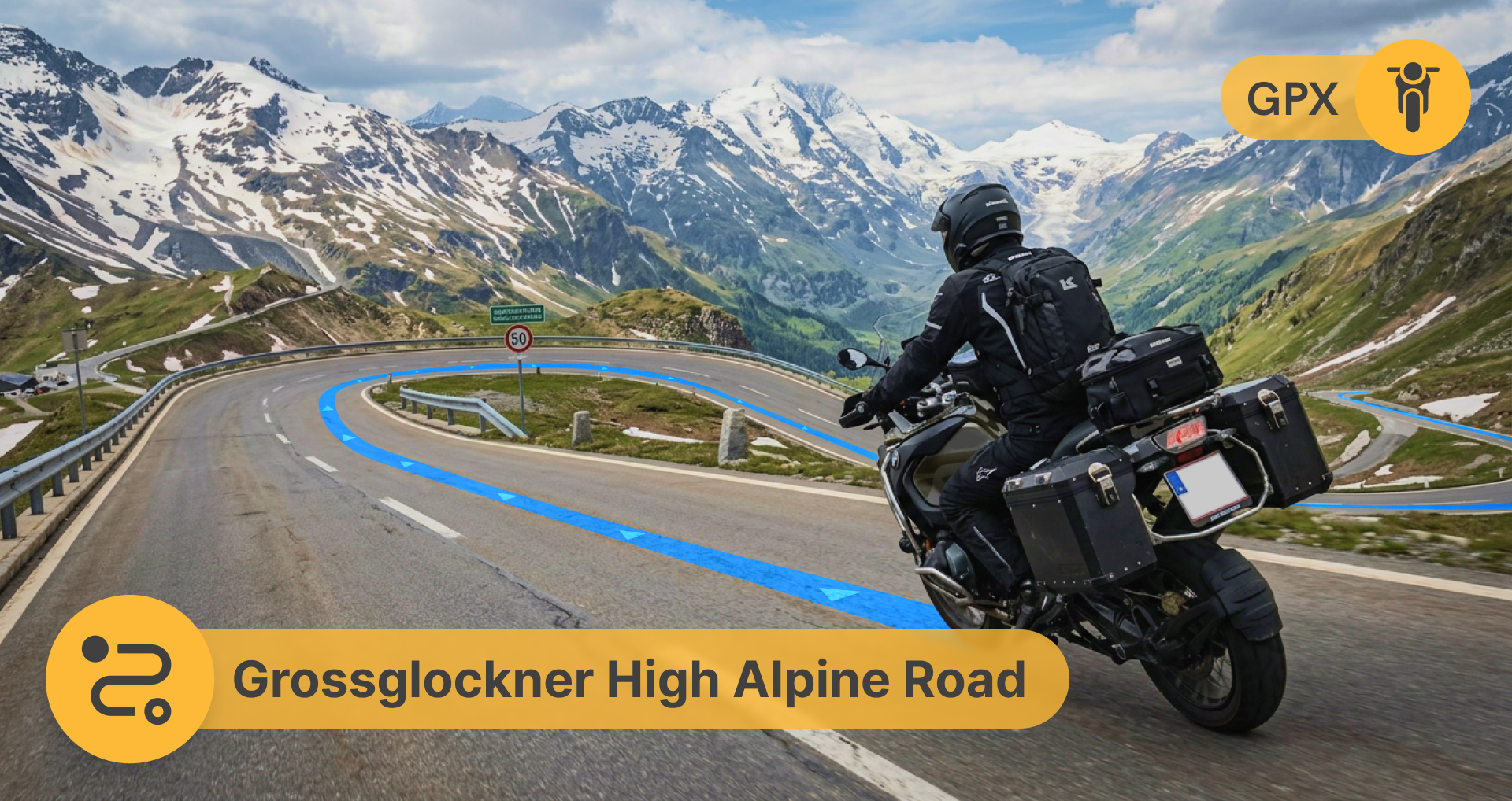
Grossglockner High Alpine Road: One of Austria’s Best Motorcycle Rides
Some motorcycle roads are fun. Others stay in your head long after the ride is over.
The Grossglockner High Alpine Road is one of those roads. Grossglockner is one of those rare motorcycle roads that truly lives up to the hype. Not because it’s extreme.
But because every kilometer feels made for riders.
And with the right motorcycle navigation setup, the entire experience becomes smoother, safer, and a lot more enjoyable.
Why Riders Love Grossglockner
The Grossglockner High Alpine Road connects Salzburg with Carinthia through the Austrian Alps.
What makes it special for motorcyclists?
- flowing mountain curves
- dramatic elevation changes
- perfectly maintained roads
- panoramic viewpoints
- pure riding rhythm
It’s the kind of route where every corner feels rewarding.
Quick Rider Facts
- Country: Austria
- Road Length: ~48 km
- Highest Point: 2,504 m
- Best Season: June – September
- Road Type: Scenic alpine toll road
GPX Route for Grossglockner
Planning alpine rides becomes much easier with GPX routes. Simply import the route into Sygic GPS Navigation and start riding.
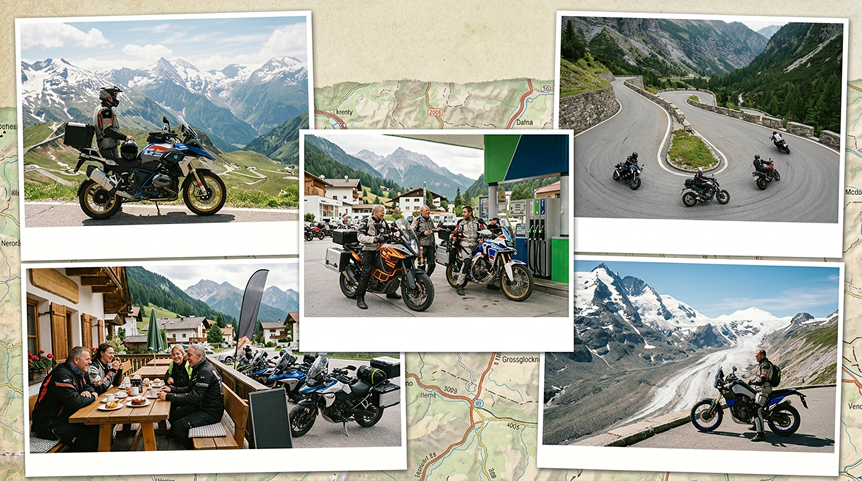
This route starts in Bruck an der Großglocknerstraße, one of the most popular gateway towns for riders entering the Austrian Alps. After leaving the valley behind, the road begins climbing through smooth sweeping curves and classic alpine scenery.
The first major stop is Fuscher Törl, a legendary rider viewpoint surrounded by dramatic mountain peaks. From there, the GPX route takes you to Edelweißspitze, one of the highest accessible points on the road with panoramic views over the Alps and cobblestone curves every motorcyclist remembers.
Continuing south, the route passes through high alpine sections with incredible glacier scenery before reaching Kaiser-Franz-Josefs-Höhe, the perfect place for a coffee break and views of the Pasterze Glacier.
The ride finishes in Heiligenblut, a beautiful alpine village known for its iconic mountain church, relaxed atmosphere, and rider-friendly cafés — the ideal stop before continuing deeper into the Alps or heading back home.
Recommended Stops Along the Route
- Bruck an der Großglocknerstraße
- Fuscher Törl
- Edelweißspitze
- Kaiser-Franz-Josefs-Höhe
- Heiligenblut
What’s Included in the GPX Route
- scenic alpine viewpoints
- twisty mountain sections
- fuel stops
- rider-friendly coffee stops
- glacier viewpoints
Tips Before You Ride
Start Early
During summer, traffic builds up quickly.
Morning rides usually mean:
- quieter roads
- cooler temperatures
- better visibility
- fewer tourist buses
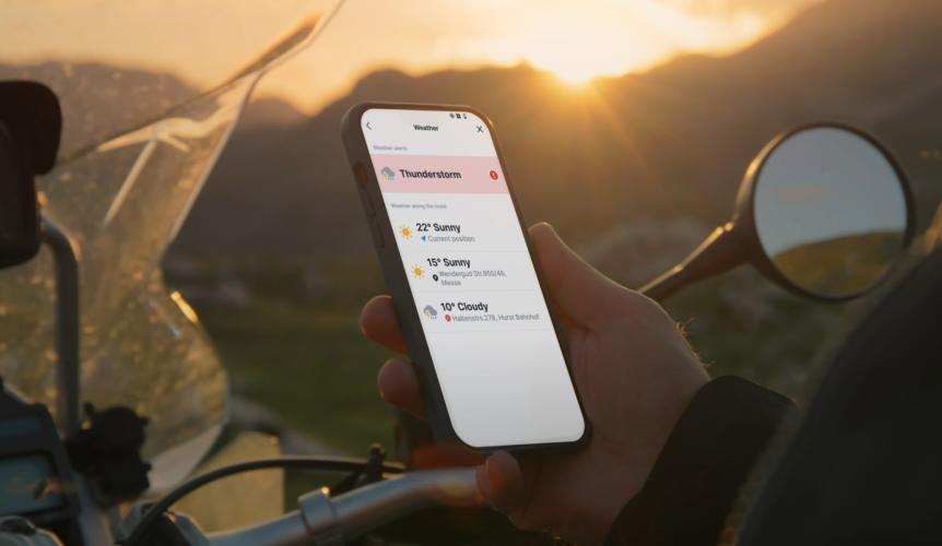
Weather Changes Fast
In the Alps, sunshine can turn into fog or rain surprisingly quickly.
Checking weather conditions before climbing into higher elevations is essential.
This is where Motorbike Mode becomes especially useful.
With Weather Info on Route, riders can check current weather and forecasts directly along the ride before conditions become difficult.
Offline Navigation Matters in the Mountains
Mobile signal can disappear quickly in alpine areas.
Downloading offline maps before the ride helps avoid:
- navigation interruptions
- roaming issues
- losing signal in tunnels
- unnecessary battery drain
For mountain riding, offline motorcycle navigation is simply a must-have.
Why Grossglockner Is Perfect for Motorbike Mode
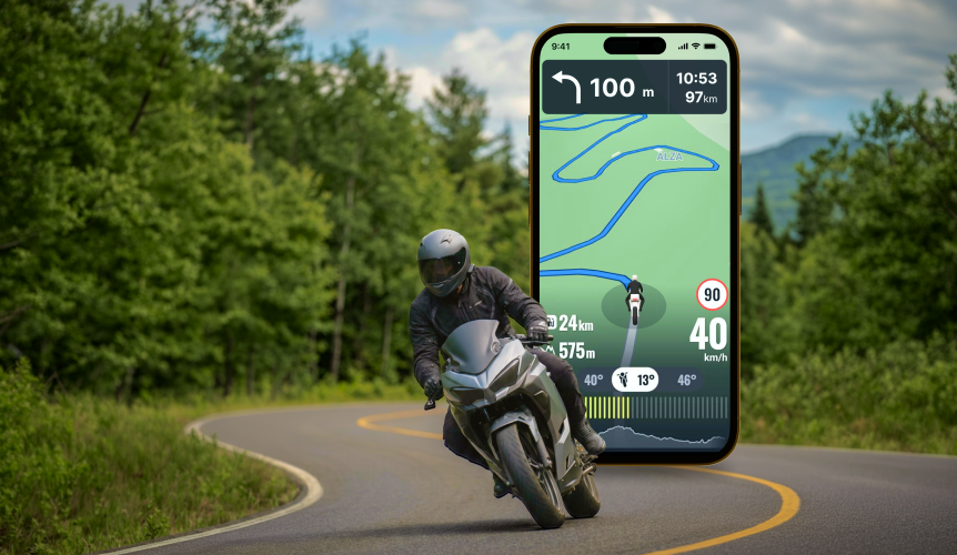
Routes like Grossglockner are exactly where motorcycle-focused navigation features make the biggest difference.
Twisty Route
Grossglockner isn’t about highways. Using Twisty Route helps riders discover more scenic alpine roads instead of boring transit sections.
More curves. Better riding.
Elevation Data & Terrain Profile
With major altitude changes throughout the route, real-time elevation data helps riders better understand upcoming climbs and descents.
And honestly - watching your altitude climb through the Alps is part of the fun.
Fuel Stations on Route
Fuel stops in mountain regions aren’t always frequent.
Seeing nearby gas stations directly on the route makes longer motorcycle trips across Austria much easier to manage.
Glove-Friendly Navigation
Mountain riding means quick glances at the screen, changing weather, and gloves always on.
The simplified navigation screen with larger controls makes route management much easier while riding.